Thursday, September 8, 2022

ALASKA - PART 4

ALASKA FROM NORTH TO SOUTH 

Our next excursion was to return to all the way south to Anchorage for an Alaska Airlines flight all the way north to the Top of the World:  Utquiavik (UUT-kee-AH-vik), formerly known as Barrow.  We could have taken a scheduled bush plane from closer Fairbanks, but that was a milk-run that took twice as long at four times the cost.

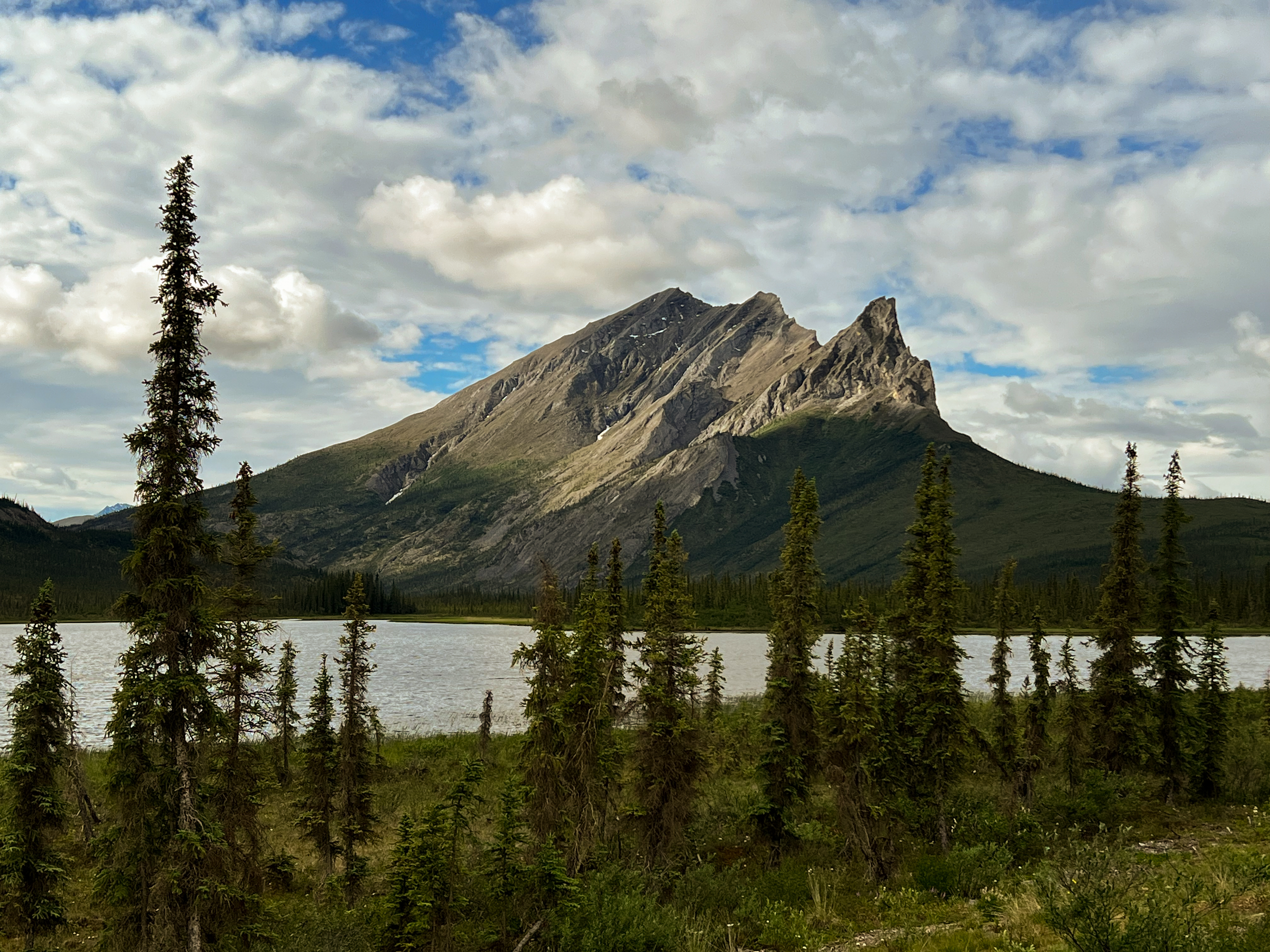
On boarding in Anchorage we accidentally sat on the wrong side of the aisle.  But when the rightful occupant informed us we readily acknowledge it and offered to move.  But he seemed to not want to be bothered and sat across the isle.  Our flight north flew over the Alaska Range, and although we didn't stop to see Denali from the ground we were rewarded with an excellent overhead view.  Flying into Utqiavik across the tundra and melt ponds on the permafrost in June we knew we were seeing geologic-time in our lifetime.  

Denali, the Great One, in the Alaska Range

Yukon River and Yukon Flats

In June snow is already melted and ponds, unable to drain due to permafrost

Utqiavik has just over 5000 people, the twelfth largest municipality in the state.  Most are Inupiat eskimos and subsist on hunting and fishing.  To combat addiction that the isolation, cold, and darkness can create, the village counsel limits the amount of alcohol that an individual can purchase/month at a tribal store.  For those that have had trouble with managing their intake or behavior under the influence, they cannot purchase any.  

In such a small airport the baggage area was overwhelmed with boxes and Costco-like tubs; many per passenger.  Apparently they were coming back from shopping in Anchorage.  We also suspect many tubs were work-arounds of the alcohol rules.  It was here that our innocent seat selection had impact.  While waiting for our baggage I chatted up an Inuit guide who was waiting for his guest.  The guide offered to take us to our hotel since it was the same as his client's (there's only two) - and there's limited taxi service.  When his guest arrived with his luggage he was the man who's seat we offered to vacate. He refused to engage us and made several snippy comments. I took the guide aside and said, I think it best we find other transportation.  He understood his guest type and apologized.  

We checked into Top Of The World hotel in the early evening and arranged for a tour the next day of the town and a drive out to Point Barrow, the northern most point in the US which separates the Chukchi and Beauford Seas.  After dinner we took a walk around town.  It's probably more charming in the winter when everything is white and covered with snow, and the air has that sparkling quality from any moisture freezing into mini crystals like fairy dust.  In the summer it is muddy and unkempt.  Out of necessity every property is a storage area for trucks, cars and snow-machines (not snow-mobiles!) to be used for repairing or rebuilding or inventing something needed. 

Top of the World Hotel

Nearby neighborhood.  They all look the same.

Typical yard with lots of parts need for repair or other uses.  
Buried by Snow in the winter

In the morning we met our tour guide who, it turns out, was the guide we met at the airport. And his only other guest?  the man who's seat he was now convinced we usurped.  While the day was warm, the ride was initially quite chilly, until we started having a good time with the guide while the grump sat in silence.  

Iconic whale rib arch of Utqiavik and the Arctic Ocean.  
The ice is just blown against the beach.  There's open water beyond, and far beyond that ice again

Point Barrow where the two seas meet. Beyond Arctic Ocean to the North Pole and then Russia.

We left Utqaivik for our final stop to the very south of Alaska - the Kenai Peninsula (not counting the inside passage or Aluetians Islands).  We arrived in Anchorage, rented a car and drove 2.5 hours to Seward, the departure point for Kenai Fjords N.P. tour on the east side of the peninsula.  

Turnagin Arm off Cook Inlet, and the Kenai Mountains beyond. 

Leaving Seward, AK and entering the Kenai Fjords

Pair Humpback Whales

Robin with a piece of Glacier Ice - for cocktails

Glacier Ice Cocktail

This is very cool.  The humpbacks fish together circling underwater
and blow bubbles that trap the fish in a "bubble net".  
They then surface through the center with mouths agape.  
(See center left of one open mouth out of the water.)  
The birds know when this will happen and flock there to get missed fish.

Beautiful rock formations inhabited by a variety of pelagic birds - including the colorful Puffin.

We had planned to go king salmon fishing on the Kenai river the next day so we booked a room on the west coast of the peninsula in Soldotna, Russian for soldier.  But a week before we left we were advised the salmon runs were small and the state canceled fishing early.  Instead we drove to the End of the Road in Homer and went bear watching.

Homer is a popular sea fishing port. 

Mom and a couple cubs at Lake Clark N.P. across from Homer.

Our captain was about twenty years old and his two crew were girls fifteen and eighteen.  Soon they were sharing their life in Alaska.  Both have successfully hunted bear with their father and, being my kind of dad, he said "you killed it, you pack it out".  So this petite young woman humped a 200# bear out of the woods - and then butchered it.  She showed us the photo of the dead bear across her back.  Hauling Robin across the surf to the boat ramp was nothing.   

Robin, being lighter than a bear, is carried across the surf to the boat ramp.

Our last day we crossed the peninsula and drove up Turnagin Arm again.  Along the road several cars were pulled over.  We finally got our first real sighting of a moose lazily wading through the marsh.  Majestic - if not a little concerning when he briefly walked toward us before heading into the woods.  

Finally, we see a moose.  

Next Post:  Maybe Czech Republic - in a couple months.


ALASKA - PART 3

COMING INTO THE COUNTRY

Beside Alaska's beauty, I was struck again by the vastness of its wilderness.  In Washington Cascade and Olympic mountains you only need to hike a short distance in designated Wilderness or Forest Service lands before you come across wires or roads that lead you back to civilization. You hardly left.   In Alaska, you only need to travel a short distance out of populated areas to plunge you into vast untracked wilderness of a completely different scale - larger than most states.  Six of the ten largest US National Parks, and the top four, are in Alaska.  This doesn't count other untracked areas.  

Alaska is HUGE!  Two and a half times the size of Texas, and superimposed on the continental US it stretches from the S.F. Bay area to northern Minnesota and down to Florida.  

Over half of all visitors to Alaska arrive on cruise ships up the Inside Passage. Many travel north as far as Denali N.P. outside Anchorage, or south to Kenai Peninsula, both in South Central Alaska.  (See map below). Only one-half of one percent of 2019 visitors traveled north of the Arctic Circle to the Brooks Range and Gates of the Arctic N.P. or beyond - our next destination.


My book for this trip was "Two in the Far North" by Margaret (Mardy) Murie.  She was raised in Fairbanks in the first decades of the twentieth century, married the biologist Olaus Murie, and in the twenties through forties traveled the Interior and Far North by dog-sled in the winter assisting with his research.  Mardy became a conservationist and author who helped preserve millions of acres of land in Alaska.  She testified before Congress for the creation of the Arctic National Wildlife Refuge and passage of the Wilderness Act.  Our itinerary will stop at several places they traversed.  A wonder to see through her eyes a century ago in the dead of winter.  Well worth the read.

After leaving our friends in Juneau, we flew to Fairbanks on the solstice.  This is still south of the Arctic Circle but the sky never darkened.  Here In the Country, we discovered Alaskans are an odd group.  Outside the native population, they seem here for the love wilderness, to exploit resources, to be self-reliant, or are a bubble off - or several of the above.  Checking into our Fairbanks hotel our host couldn't make eye contact and hardly spoke - and this is in "hospitality" work.  We took an Uber to a nearby pizza place as downtown has no there there.  The driver had a mountain-man beard (as do most men here), a nervous twitch, wild eye, and spoke obtusely.   

Typical Fairbanks truck at dinner.  Enlightened and woke.

The next morning we boarded our tour bus to travel the Dalton Highway to the Arctic Circle. Our bus driver was a chatty pleasant fellow, but awkward.  He was tall and heavy-set, but explained that before he moved here he was eighty pounds heavier. From him we learned about dry-cabins, damp-cabins, and wet-cabins, among other homesteading essentials.  Dry means they have no water, all water is carried in for bathing and cooking, and necessities are in an outhouse.  Wet-cabins are fully plumbed, and damp is in-between, maybe domestic water but still an outhouse.   We heard that most everyone outside the cities live in a dry-cabin.  We also were informed about the pipeline and stopped to examine one section for a stretch-the legs-break.

Little Tour Bus and driver

Alaska Pipeline with "radiators" on the posts to dissipate heat from permafrost.

We changed transportation at the Arctic Circle to continue on to Coldfoot.  Most of the twelve or so passengers were only going to cross latitude 67 - over sixteen hour RT ride for their Instagram moment.


Alaska Taiga with stunted Black Spruce and the Pipeline snaking in the distance

Our Instagram moment (If we had Instagram)

The Dalton Highway, also called the Haul Road, is 400 miles long through otherwise inaccessible wilderness from Fairbanks to Deadhorse on the Arctic Ocean. It is the only road in the Far North, and except for some local roads on the coast there is nothing west of Anchorage to the Bering Sea.  Three quarters of the state is roadless.  This is why the remarkable Bush Pilots are such a fearless necessity.  

The Haul Road was built in 1974 through taiga and tundra, and over the 4800' Atigun Pass, in only five months!  The sole purpose was to transport building supplies and workers to construct the pipeline adjacent to it, and to the North Slope oil fields.  The whole pipeline runs 800 miles from Prudhoe Bay on the Arctic Ocean to Valdez on Prince William Sound (remember Exxon Valdez).  Oil started flowing in 1977.  Remarkable what humans can accomplish when short-term profit is involved, sadly less so when the threat is not immediate but existential.  The haul road is still mostly gravel and used almost exclusively by long-haul truckers year-round, and at high speeds.  It only opened up to the public 1994 after Alyeska, the oil consortium that built it, donated it to the state.  Our "little tour bus" would announce itself that way on the CB at every bend or rise in the road to inform the on-coming hurtling behemoths.  

Long haul truck hauling ass. 

Ten hours after leaving Fairbanks we arrived in the early evening in Coldfoot - but still in bright sunlight.  Coldfoot was a small settlement on the Koyukuk River river that Mardy and Olaus passed through after weeks traveling and camping on the frozen Yukon and tributaries.  It was named not because of frostbitten feet, but rather after living a winter here, many settlers got "cold feet", IE fearful, and left.  Coldfoot now is only a wide spot in the road for truckers to take a break and get a meal.  The only accommodation is former pipeline-worker housing - basically trailers cobbled together that still smell of diesel.  It's also the home for the Interagency Visitor Center for the Gates of the Arctic N.P. and other federal lands north of Denali.  I love Federal Visitor Centers;  they are informative, have great topical books/maps and the people are very friendly - this was no exception.  

Coldfoot - essentially a truck stop

Our Dorm Room

Robin uncertain about a meal with no wine - only Bud.  
The Alaska shaped sign on the bar says "Furthest North Saloon in the US"

After arriving, settling into our dorm room, and dining on the buffet with truckers we boarded a six-seater just before 10:00 at night for an hour plus air-tour of Gates of the Arctic N.P.  There are no trails or roads as mentioned, so by air is the only way to see it without weeks of hiking cross-country in bug-infested bear country.  Despite the late hour it was gorgeously lit by the circling sun and confused rain clouds.  

Flight under heavy clouds over Gates of the Arctic N.P. 
Note the lack of trees.

Higher peaks and river valleys that twist and turn in Gates of the Arctic N.P.

Vastness of Gates of the Arctic N.P.

Our next day we scheduled a drive to Atigun Pass, about two hours north on the Dalton Highway.  This pass over the Brooks range separates the taiga (with stunted Black Spruce trees) from the North Slope tundra (all growth within six inches above or below the surface).  Our driver was a nice young man from rural Colorado.  He and his wife are year-round residents for their second season.  They homestead, love exploring the outdoors, guide and have an on-line business making jewelry for additional income.  Like all up here, they live in a dry cabin.  Having only lived in Alaska for two years they were delightfully normal and conversant.  When you think about it, Coldfoot is twelve hours from any rescue or assistance if needed.  Living in the wilderness, like this young couple, requires self-reliance.

Black Spruce and Sukakpak Mountain heading to Atigun Pass

Pipeling winding up to Atigun Pass

Long Haul trucker cresting Atigun Pass on way to Prudhoe Bay

Returning from Atigun Pass we stopped at Wiseman, about 10 miles north of Coldfoot on the Koyukuk River where Marty and Olaus were finally able to sleep in a warm cabin welcomed by homesteaders after weeks camping in sub zero weather.  It still has only about twelve year-round residents.  The most famous is Jack Reakoff and his wife.  Their refrigerator is in the permafrost crawl space accessed through a hatch in the kitchen floor.  They grow their own vegetables, mostly roots for winter storage, and both hunt their own food.  He said their diet is about 80% meat.  Totally self-sufficient.  

Homesteader cabin, Wiseman

Homesteader Cabin, Wiseman

Jack Reakoff explaining the need for self-reliance being twelve hours from anywhere.

Jack Reakoff's living room.  Note upper left mountain sheep.  
Jack is a strong supporter of a hunt ban as their population is plummeting.

For our last day, our driver's wife took us on a pack-rafting trip, which I'd never done before, but is common here.  Basically, you roll an inflatable kayak into a pack, hike to a river, inflate it, and then float the river.  Delightfully peaceful for two hours. Robin kept her eye out for moose along the shore having never seen one.  During our drive last year through Canada we constantly saw Caution Signs with the moose outline.  However, they are elusive and we didn't see any along the river.... or in Canada.

Robin fully bug protected and ready to pack it in.

Floating the Koyukuk River to Wiseman.

Next Post:  Alaska - North to South

Wednesday, September 7, 2022

Alaska - Part 2

INSIDE PASSAGE

At 6:00 pm on June 15th the Alaska Marine Highway ferry left Bellingham, WA, near the Canadian boarder.  Similar to 1988, the next morning was drizzly with low overcast;  perfect to capture the feeling of SE Alaska, though we were still between Vancouver Island and mainland BC.  However, this time we did not camp on the deck, we had a cabin.

Inside Passage first full day with Aaron, Kate, intrepid author, and Robin.

Our second morning we arrived in Ketchikan at 6:30 am on a cloudless day.  We walked the couple miles into town, got a cup of coffee, and by the time we cruised the boardwalk it was busy with tourists.  For those that haven't been, Ketchikan is a cute little town clinging to the cliffs with the boardwalk elevated above the sea.  It's also where the Bridge to Nowhere was proposed to connect the airport on a gravel bar with the mainland.  Its economy was based on mining and fishing, then timber and fishing, and now tourism and fishing - but tourism by far and away is the economic driver.  

Ketchikan Boardwalk

A large Holland America cruise ship was docked and had disgorged hordes of overweight, camera snapping, multi-ethnic tourists.  There were plenty of plaques describing Ketchikan's history and culture, but hardly any shore-leavers stopped to read them. The boardwalk was lined with sweatshirt, bubble ice-tea, and fish and chip shops.  There were also beautiful local arts and crafts by the indigenous peoples.  When I came here for work in 1997 at the end of the tourist season, I was told shop owners left to winter in Arizona.  Ketchikan gets twelve FEET of rain a year while Seattle gets just over 36 inches.  A lovely town, but pretty one dimensional.  Eye candy, not a meal.  

Our next stop was Wrangle at 3:30 pm.  While I couldn't live here, it seemed delightfully real.  Kids bicycling gravel roads, grocery store, and houses in various states of repair. The only thing for tourists, and the locals, was an ice cream cum sushi shop.  Only in Wrangle would you combine those two.  

Main Street, Wrangle

Homes in various states of weathered disrepair

We didn't get off at the last stop of the day, Petersburg, as it was dinner time.  But Petersburg is of note because of its strong Norwegian heritage which still lives on.  Ironic, since it was founded by the Russians and thus named.  

Petersburg and boat launches

We arrived in Juneau on the third morning at 4:30 am.  Being north now, and close to the solstice, it was already daylight.  The ferry dock is six miles from the town center, and the airport is between the two.  We had a 9:00 am flight on a small puddle jumper so we killed time with breakfast at Donna's Restaurant near the airport where I dined on reindeer sausage with biscuits and gravy.  Excellent!  We boarded our flight for the 20 minute hop to Gustavus, the gateway to Glacier National Park, and from sunny skies to drizzle.  

Mendenhal Glacier outside Juneau from plane window

We were picked up at the gravel runway in Gustavus by a pleasant chatty woman.  As she went over the details of our stay she informed us there was no alcohol at the Inn, but she'd be glad to buy us what we wanted in "town" which, we discovered, consists of three buildings.  Used to working with hoteliers, it seemed odd for a lodge to miss out on this revenue stream, but we didn't think much about it. We arrived at Glacier Bay Inn, an oddly shaped, owner design/built, series of cabins, lodge/restaurant, and out-buildings near an abandoned and overgrown airstrip.  Clearly, no building permits for this project.  The logs were felled and milled on site, interior walls were half finished, and the design seemed very ad hoc. 

Welcoming entry to lodge

Unfinished Dining Room deck overlooking former airstrip.

That afternoon went to the marina and walked the shoreline to a Tlingit tribal house.  We had an informative tour of the art work and local culture by a member of one of the four main Tlingit tribes. Later, the lodge owner complained about how much the Federal Government spent on the construction.  But we thought it beautiful and minor compensation in the scheme of buying all Alaska in 1867 from Russia for $7 million - without consulting the inhabitants for thousands of years.  

Tribal house for four Tlingit Tribes

Interior of Tribal house where each of four supporting poles tell the stories of each tribe

During dinner at the lodge overlooking the former airstrip we met many other staff; all young and from Arizona.  They were very nice with innocent beatific smiles.  As we looked around we realized we were the only ones with wine for dinner.  Bantering with one of the girls stumbling with the wine, she said something like "Oh, I don't know anything about this - I don't drink".  

Very sweet helper.  

Not unusual, but slowly we connected the dots and realized the owners, the staff, and most guests were Mormon.  Later, the pleasant chatty woman who picked us up confirmed our suspicions. It turned out the small community of Gustavus is a predominantly Mormon with strong connections to Arizona.  As the only non-Mormon staff, she was the designated enabler for the gentiles. Mormons historically gravitate to remote areas without much government oversight in UT, AZ, ID, and BC, so it's fitting they'd settle off the grid Alaska. (Read "Under the Banner of Heaven" by Jon Krakauer for a true murder mystery, and a contemporary and historic view of this religion.) 

Our next day was an eight hour round trip boat tour of Glacier Bay N.P.  What's quite remarkable about reaching my late 60s is to see Geologic Time happen in our life-time.  Meaning things that have taken tens of thousands of years or even millions, happen in several hundred - or a mere sixty eight.  I first visited Glacier Nat'l Park in MT in 1973 and on our drive trip last year we saw that many glaciers have drastically shrunk since then; expected to be gone before I am.  I remember in the 70s seeing Nat Geo articles of the shrinking Aral Sea off the Caspian, and it is now almost entirely dried up.  And Glacier Bay shows what glacier retreat will look like shortly for Mt Rainier and the Cascades where we live, not to mention the Alps, Andes, and Himalaya where they've closed climbing routes due to avalanche danger.  It's compressed time for us all to ponder.  


The boat tour took hours to reach the glacier terminus, but during the passage we saw many whales, seals, mtn. sheep, otters, puffins, and even bears celebrating the connubial rights of spring.  

Seals lounging

Bear voyeurism - watching conjugal visits on shore.

At glacier terminus in the water. 

Glacier calving shrinking further.

The day following the boat tour we returned to Juneau; our friends continued on to Anchorage for their trip to Denali and the Kenai Peninsula.  We stayed one night in the hotel I remodeled thirty-eight years before.  "You can never go back" makes sense only if you expect things be the same.  I don't, and therefore find it life-affirming.  The hotel is still there along with many of the design creations we implemented.  But it also changed.  The operator changed.  The uses changed.  The lovely elegant lounge and piano bar we designed is now just a haphazard assemblage of furniture without a soul.  

The town is pretty much the same but more geared toward tourism.  But our tour of the capital was rewarding with unique history and lovely Alaska art. 

Main street of Juneau

The entry to the Art Deco Baranof Hotel.  
The only exterior design we did in 1984 was the canopy.  

Alaska State Capital with statue of William H. Seward,
Lincolns V.P. who purchased Alaska for the US from Russia in 1867.

Next Post:  Coming into the Country - North of the Arctic Circle